


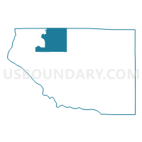
RIVER FALLS - T 1 Voting District, Pierce County, Wisconsin
About
Outline

Summary
| Unique Area Identifier | 696148 |
| Name | RIVER FALLS - T 1 Voting District |
| County | Pierce County |
| State | Wisconsin |
| Area (square miles) | 36.19 |
| Land Area (square miles) | 36.16 |
| Water Area (square miles) | 0.03 |
| % of Land Area | 99.92 |
| % of Water Area | 0.08 |
| Latitude of the Internal Point | 44.82080290 |
| Longtitude of the Internal Point | -92.55936900 |
Maps

Graphs
Select a template below for downloading or customizing gragh for RIVER FALLS - T 1 Voting District, Pierce County, Wisconsin


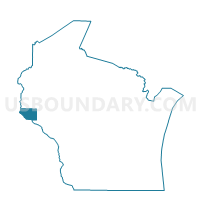
Neighbors
Neighoring Voting District (by Name) Neighboring Voting District on the Map
- CLIFTON - T 1 Voting District, Pierce County, WI
- ELLSWORTH - T 1 Voting District, Pierce County, WI
- KINNICKINNIC - T 3 Voting District, St. Croix County, WI
- MARTELL - T 2 Voting District, Pierce County, WI
- OAK GROVE - T 2 Voting District, Pierce County, WI
- PLEASANT VALLEY - T 1 Voting District, St. Croix County, WI
- River Falls - C 11 Voting District, Pierce County, WI
- River Falls - C 7 Voting District, Pierce County, WI
- River Falls - C 8 Voting District, Pierce County, WI
- RIVER FALLS - T 2 Voting District, Pierce County, WI
- TRIMBELLE - T 1 Voting District, Pierce County, WI
Top 10 Neighboring County Subdivision (by Population) Neighboring County Subdivision on the Map
- River Falls city, Pierce County, WI (11,851)
- River Falls city, St. Croix County, WI (3,149)
- River Falls town, Pierce County, WI (2,271)
- Oak Grove town, Pierce County, WI (2,150)
- Clifton town, Pierce County, WI (2,012)
- Kinnickinnic town, St. Croix County, WI (1,722)
- Trimbelle town, Pierce County, WI (1,679)
- Martell town, Pierce County, WI (1,185)
- Ellsworth town, Pierce County, WI (1,146)
- Pleasant Valley town, St. Croix County, WI (515)
Top 10 Neighboring Place (by Population) Neighboring Place on the Map
Top 10 Neighboring Unified School District (by Population) Neighboring Unified School District on the Map
- River Falls School District, WI (22,944)
- Ellsworth Community School District, WI (11,180)
- Prescott School District, WI (7,824)
Top 10 Neighboring State Legislative District Lower Chamber (by Population) Neighboring State Legislative District Lower Chamber on the Map
- Assembly District 29, WI (66,814)
- Assembly District 30, WI (66,575)
- Assembly District 91, WI (56,636)
Top 10 Neighboring State Legislative District Upper Chamber (by Population) Neighboring State Legislative District Upper Chamber on the Map
Top 10 Neighboring 111th Congressional District (by Population) Neighboring 111th Congressional District on the Map
Top 10 Neighboring Census Tract (by Population) Neighboring Census Tract on the Map
- Census Tract 9605, Pierce County, WI (7,892)
- Census Tract 9602, Pierce County, WI (5,996)
- Census Tract 9603, Pierce County, WI (5,667)
- Census Tract 9604, Pierce County, WI (5,192)
- Census Tract 9606, Pierce County, WI (4,857)
- Census Tract 1209.01, St. Croix County, WI (4,121)
- Census Tract 1209.04, St. Croix County, WI (4,036)